Hike Location and Carpool
Attending: 0
Maybe Coming: 0
Not Coming: 0
Sunday
May
22
2011
Oakland Hidden Woods to Redwood Peak
- Organized by
- Mike

- Location
- Location not specified.
- Time
- 11:00 AM - 4:30 AM
- Miles
- 9
- Feet of Elevation
- 1100
Share route
Hiking Route: Sausal Creek to Redwood Peak
Loading Route map...
Approximate route statistics:
Please note that Mileage and Cumulative Elevation Gain are approximate, and are shown FOR REFERENCE ONLY. The actual numbers will be 10-50% higher, depending how accurately hike organizer plotted the route. Unless you can walk - no, FLY! - a perfect straight line!
Please note that Mileage and Cumulative Elevation Gain are approximate, and are shown FOR REFERENCE ONLY. The actual numbers will be 10-50% higher, depending how accurately hike organizer plotted the route. Unless you can walk - no, FLY! - a perfect straight line!
Hiking Route Description:
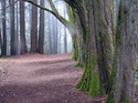
This is very much an approximation, but you get the general idea. The mileage will be more like 4-4.5 each way with all the actual trail bends and twists, and the net elevation gain is about 1100 feet. The point of the hike is starting in the suburbs, getting surprisingly far into the woods, and achieving a genuine flatland-to-peak on-foot experience. The little jog toward Castle Drive is to stop for lunch with a terrific panoramic view of the Bay Area--be warned, there is no such view from the Peak, just a sense of accomplishment among some fantastic Redwoods.
Hike Description:
--Please take a moment to review http://kermitbubbleboy.net/temp/Mikes_Hike_Facts/HIKE_FACTS.html_________________________________________________________
This hike is a 9 mile out-and-back from an urban Oakland city park to Redwood Peak, an ascent and then descent of slightly over 1100 feet. The ascent is mostly a gentle-to-moderate climb with several brief stretches of steepness and/or steps. The surprise treat here is that the vast majority of the trail feels very woodsy because, though we are deep in Oakland, the Sausal Creek corridor is a lovely strip of nature and the Palos Colorados trail has some sections that rival the Soda Gulch trail on the Peninsula and the French Trail in Redwood Park for sheer forest majesty. As an out-and-back, it's easy for hikers to quit early and head back down the trail whenever they wish, but to keep things interesting for those who prefer the whole tour, we generally take one section of the Big Trees trail in Joaquin Miller on the way up and a different route through that park on the way down. We try to do lunch with a panoramic view around 12:30 in Joaquin Miller, about 2/3 of the way to the Redwood Peak--be warned, city-slickers, with even a medium sized group we eat sitting on the ground by the trail ;)
Meet by the Dimond Pool in the center of Dimond Park. There is usually, but not always, plenty of parking on surrounding streets, so it would be wise to arrive at 10:45 in case there are events in the park that make parking more difficult than usual.
Comments
Hey!
Anyone put off by the lack of attendance here should know there are at least 10 or 15 folks from the East Bay Casual Hiking Group planning to show up :) You won't be alone!
To Post a Comment,
Login or Create an Account